![toronto intersections]() It's fun to watch Toronto intersections change and evolve. The ability to scroll forward and backward through time on the popular Esri historical map of the city is an excellent illustration of how the old city has expanded beyond its former boundaries, but maps and plans only tell part of the story. Photos help fill the gaps, illustrating how the places we know came to be.
It's fun to watch Toronto intersections change and evolve. The ability to scroll forward and backward through time on the popular Esri historical map of the city is an excellent illustration of how the old city has expanded beyond its former boundaries, but maps and plans only tell part of the story. Photos help fill the gaps, illustrating how the places we know came to be.
While some transformations have been dramatic--Danforth east of Pape, for example--others have remained, against the odds, relatively untouched: King and Spadina has sported the same cluster of buildings at its northwest corner for more than a century and Queen and Broadview remains familiar thanks to Dingman's Hall (Jilly's to its friends.)
Here are 10 more intersections as they were (roughly) 100 years ago.
See also: 10 key Toronto intersections as they were 100 years ago
Queen and University
In 1924 when this photo was taken, University ended abruptly at Queen, just south of the Boer War memorial. It wasn't until 1931 that the road was extended south to Front as part of a scaled back beautification plan for the downtown core. Had it been fully realized, several Parisian-style avenues and a grand interchange reminiscent of Picadilly Circus would have been built south of Queen between Simcoe and Yonge. Today, the Canada Life Building dominates the same view.
Baldwin and Kensington
![toronto baldwin kensington]() The corner of Baldwin and Kensington on October 7, 1919 looking west. Kensingtons espresso bar has replaced the home on the left. There's still a grocery store on the corner behind the boy, albeit in a different building. When this photo was taken Kensington was a predominantly Jewish neighbourhood. Kosher butchers, grocers, and bakers lined the narrow streets of tightly packed Victoria homes. By the end of the 1920s, Kensington would be the centre of Jewish life in Toronto.
The corner of Baldwin and Kensington on October 7, 1919 looking west. Kensingtons espresso bar has replaced the home on the left. There's still a grocery store on the corner behind the boy, albeit in a different building. When this photo was taken Kensington was a predominantly Jewish neighbourhood. Kosher butchers, grocers, and bakers lined the narrow streets of tightly packed Victoria homes. By the end of the 1920s, Kensington would be the centre of Jewish life in Toronto.
King and Spadina
![toronto king spadina]() Considering more than a century has passed, the northwest corner of King and Spadina looks remarkably similar. The Falconer Hotel is still standing as the closed Global Village Backpackers (the historic building is currently being renovated and will later be office and retail space.) In the early years of the 20th century the Spadina streetcar didn't have its own right of way and only reached as far south as King.
Considering more than a century has passed, the northwest corner of King and Spadina looks remarkably similar. The Falconer Hotel is still standing as the closed Global Village Backpackers (the historic building is currently being renovated and will later be office and retail space.) In the early years of the 20th century the Spadina streetcar didn't have its own right of way and only reached as far south as King.
Danforth and Pape
![toronto danforth pape]() Danforth and Pape looking like a frontier town on July 7, 1913. The same view today, at the east end of Greektown towards Donlands, is completely unrecognizable. Those winding tracks would become the Danforth streetcar line and eventually the Bloor-Danforth subway. Within 10 years of this photo both sides of the Danforth beyond Pape would be developed.
Danforth and Pape looking like a frontier town on July 7, 1913. The same view today, at the east end of Greektown towards Donlands, is completely unrecognizable. Those winding tracks would become the Danforth streetcar line and eventually the Bloor-Danforth subway. Within 10 years of this photo both sides of the Danforth beyond Pape would be developed.
Eastern and St. Lawrence
![toronto eastern lawrence]() Construction of the Eastern Avenue ramps over the Don River has completely changed the streets interaction with St. Lawrence St., a small and once heavily industrial street that runs south from King. The old intersection is currently under heavy construction, but when the West Don Lands is development is complete this view will include a new park.
Construction of the Eastern Avenue ramps over the Don River has completely changed the streets interaction with St. Lawrence St., a small and once heavily industrial street that runs south from King. The old intersection is currently under heavy construction, but when the West Don Lands is development is complete this view will include a new park.
Queen and Broadview
![toronto queen broadview]() Queen and Broadview has been a key transit interchange for almost as long as Toronto has had streetcars. Today, the intersection is where the 504 King and 501 Queen streetcars go their separate ways, but in June, 1918, it also served the defunct Broadview line. That year Dingman's Hall was home to a branch of the Royal Bank of Canada on the ground floor and conventional hotel rooms above. By the 1970s the building had completed its transformation into bawdy strip club.
Queen and Broadview has been a key transit interchange for almost as long as Toronto has had streetcars. Today, the intersection is where the 504 King and 501 Queen streetcars go their separate ways, but in June, 1918, it also served the defunct Broadview line. That year Dingman's Hall was home to a branch of the Royal Bank of Canada on the ground floor and conventional hotel rooms above. By the 1970s the building had completed its transformation into bawdy strip club.
Eglinton and Old Forest Hill Rd.
![toronto eglinton bathurst]() A hundred years ago, Eglinton near Bathurst was a tree-lined strip, unpaved and quiet enough that one could walk down the middle of street without fear of being run over. Judging by the hill in the background, I would guess this image was taken at the present-day intersection of Eglinton and Old Forest Hill Rd. In 1913, both sides of Eglinton had been subdivided, but little had been built. Even a decade later very little had been built in this area.
A hundred years ago, Eglinton near Bathurst was a tree-lined strip, unpaved and quiet enough that one could walk down the middle of street without fear of being run over. Judging by the hill in the background, I would guess this image was taken at the present-day intersection of Eglinton and Old Forest Hill Rd. In 1913, both sides of Eglinton had been subdivided, but little had been built. Even a decade later very little had been built in this area.
Eglinton and Yonge
![toronto eglinton yonge]() Further proof that Eglinton was almost completely undeveloped a century ago, this view of the south side of the street just west of Yonge shows fields and trees. The construction work being carried out here is likely for the TTC streetcar yard that was located on the site of the old bus bays until construction of the Yonge subway in the early 1950s. The intersections is once again about to see transit construction, this time for the Eglinton LRT.
Further proof that Eglinton was almost completely undeveloped a century ago, this view of the south side of the street just west of Yonge shows fields and trees. The construction work being carried out here is likely for the TTC streetcar yard that was located on the site of the old bus bays until construction of the Yonge subway in the early 1950s. The intersections is once again about to see transit construction, this time for the Eglinton LRT.
Kingston Rd. and Woodbine
![toronto kingston woodbine]() Historically the intersection of Kingston Rd. and Woodbine was the centre of the former village of Norway. The community's identity was fading at the time when this photo was taken looking east towards Victoria Park Ave. in November, 1922, and now it has all but vanished (Norway Cemetery is the most conspicuous remainder.) As far as I can tell, none of the buildings in this photo remain today.
Historically the intersection of Kingston Rd. and Woodbine was the centre of the former village of Norway. The community's identity was fading at the time when this photo was taken looking east towards Victoria Park Ave. in November, 1922, and now it has all but vanished (Norway Cemetery is the most conspicuous remainder.) As far as I can tell, none of the buildings in this photo remain today.
Yonge and Lawrence
![toronto yonge lawrence]() October 19, 1922 and Yonge and Lawrence is showing the first signs of development. The streetcar tracks are part of the now-defunct Yonge streetcar that was replaced south of Eglinton by subway in 1954 and into North York by a trolley buses. 93 years later, the view is completely different. Office buildings and midrise apartments have replaced trees and gardens.
October 19, 1922 and Yonge and Lawrence is showing the first signs of development. The streetcar tracks are part of the now-defunct Yonge streetcar that was replaced south of Eglinton by subway in 1954 and into North York by a trolley buses. 93 years later, the view is completely different. Office buildings and midrise apartments have replaced trees and gardens.
Chris Bateman is a staff writer at blogTO. Follow him on Twitter at @chrisbateman.
Images: City of Toronto Archives
![]()
 Geeks, gamers, circuit benders, and new media art-heads may not always find the spaces to overlap, which makes Vector Game Art & New Media Festival's third year in Toronto all the more exciting.
  Vector 2015 runs from February 18-22. Many events are free or PWYC. Learn more on their website.
  WayHome festival, the outdoor mega-fest
  It's fun to watch
 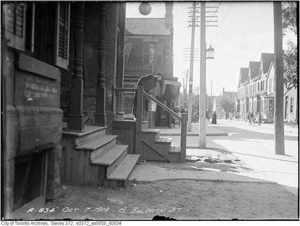 The corner of Baldwin and Kensington on October 7, 1919 looking west. Kensingtons espresso bar has replaced the home on the left. There's
 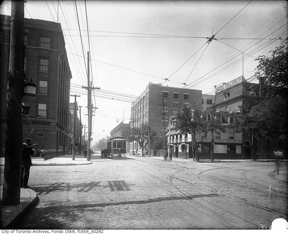 Considering more than a century has passed,
 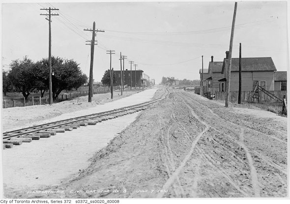 Danforth and Pape looking like a frontier town on July 7, 1913.
 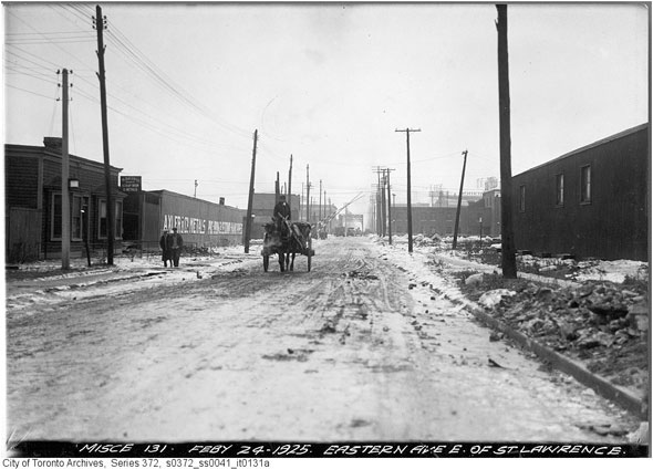 Construction of the Eastern Avenue ramps over the Don River has completely changed the streets interaction with St. Lawrence St., a small and once heavily industrial street that runs south from King. The old intersection is
 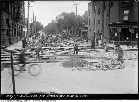 Queen and Broadview has been a key transit interchange for almost as long as Toronto has had streetcars. Today,
  A hundred years ago, Eglinton near Bathurst was a tree-lined strip, unpaved and quiet enough that one could walk down the middle of street without fear of being run over. Judging by the hill in the background, I would guess this image was taken
 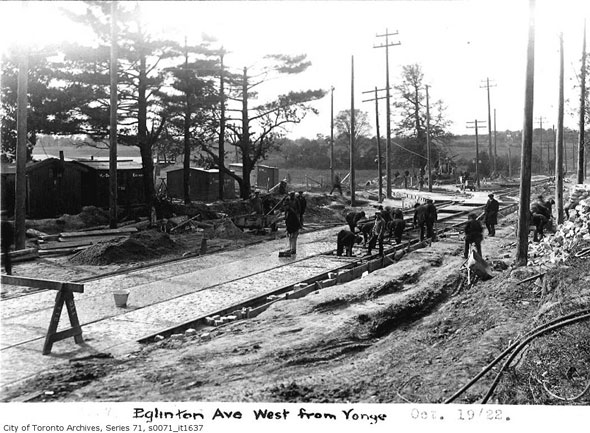 Further proof that Eglinton was almost completely undeveloped a century ago, this view of the south side of the street just west of Yonge shows fields and trees. The construction work being carried out here is likely for the TTC streetcar yard that was located on the site of the old bus bays until construction of the Yonge subway in the early 1950s.
 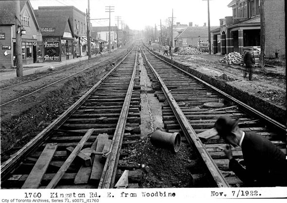 Historically the intersection of Kingston Rd. and Woodbine was the centre of the former village of Norway. The community's identity was fading at the time when this photo was taken looking east towards Victoria Park Ave. in November, 1922, and now it has all but vanished (Norway Cemetery is the most conspicuous remainder.) As far as I can tell,
 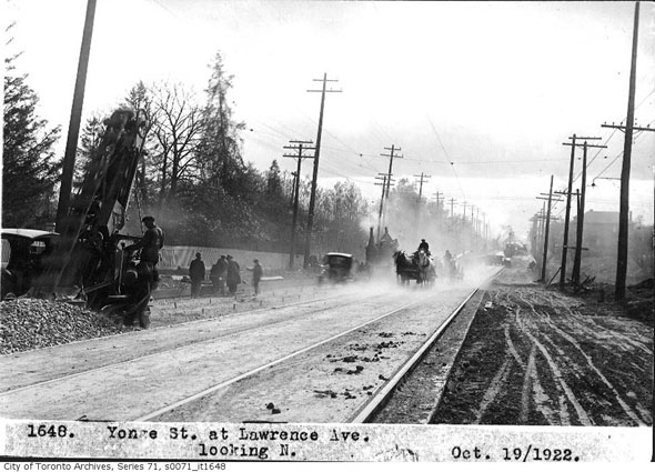 October 19, 1922 and Yonge and Lawrence is showing the first signs of development. The streetcar tracks are part of the now-defunct Yonge streetcar that was replaced south of Eglinton by subway in 1954 and into North York by a trolley buses. 93 years later,
  This Toronto burger joint distinguishes itself from the rest of the pack by serving up uniquely smoky, wood fire grilled beef patties. Other uncommon offerings include frozen custard and all natural root beer on draught.
  Aside from everything Drake touches, it's been a while since a Toronto artist released a listenable anthem for the city - the last one I remember is Blimp Rock's oh-so-cute "
 It seems like just yesterday that we were
  "When we left our original space, our choices were the Revue or Cinecycle. The Revue amused me because 'now we've hit the big time,' right? But it gives me great pleasure to work with Martin Heath at his space. It'll feel a lot more like it did when we had our own space. Me working the door, Dan 'The Mouth' Lovranski at the snack bar, kind of a secret space, much like what we were. We're really looking forward to it!"
 While Toronto's
  What is musical improv? How does it work? How do people end up in that world? If you're curious about crossing over the line from whatever comparatively cool subculture you currently call home (ska?) to the uncharted awkwardness of improvised musical theatre (I'm
 Today in Toronto, think you've got the chops to out-stack all comers? Handlebar's
  Toronto Restaurant Openings highlights the latest restaurant openings and closings in Toronto and also gives a preview of what's coming soon. Find us here every Thursday morning.
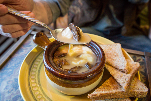 For anyone who's ever complained that there isn't enough gravy on their poutine, may I call your attention to this next specimen: Poutine Soup ($7.50), on the current menu at
  Flying solo on Valentine's Day in Toronto isn't a tragedy but if you'd rather avoid all the swooning couples and jam-packed restaurants, it's nice to find like-minded company. Whether you're looking to enjoy a dinner free of saccharine spectacles or aiming to soothe your lonely hearty with booze and loud music, this list offers options where singles like you can unite.
 According to new data released yesterday from
 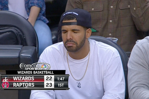 The newest Drake meme is "
 Drake is
 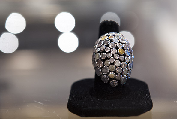 The best jewellery stores in Toronto celebrate the marriage of exquisite, precious materials with a craftsman's eye. "Precious," by the way, doesn't just mean "expensive". Though a large number of these shops do prize diamonds, sapphires, gold and silver, and cater especially to the Romeos and Juliets looking to present that special someone with some major hardware (custom or off-the-shelf), others transform more base materials into beautiful pieces that hold a different kind of value.
 If you felt like Toronto got a little more crowded over the past year, you're probably right: In addition to its steadily-growing population, the city saw its biggest-ever tourism season in 2014, a year that brought marquee events like
  Ford spun heads in January when it


